

Drone Pilot Services | Houston
Residential — Commercial — Industrial
CriticalEdge is your trusted provider of FAA-compliant aerial service, specializing in the construction, roofing, and inspection service industries across the state of Texas.
Innovative Aerial Inspection Services for Roofing and Buildings
Our advanced aerial solutions provide high-resolution imagery and detailed inspection reports, making it easier to assess roofing systems, building exteriors, and hard-to-reach areas. Whether for routine inspections or storm damage assessments, we deliver precise data to support informed decision-making.
Rapid-Response Drone Solutions for Construction Projects
Construction companies rely on CriticalEdge’s fast, efficient aerial services, powered by an established mission planning framework that ensures quick deployment and accurate data collection.
Advanced Data Solutions for Homes, Buildings and Facilities Maintenance Teams
We utilize the latest drone technology to deliver actionable, user-friendly data that helps homeowners, roofing contractors and facilities management teams assess structural integrity, identify potential issues, plan repairs and maintenance schedules. Our aerial inspections reduce risk, improving safety and increase speed obtaining actionable information.
Comprehensive Project Lifecycle Support
Our drone services support all phases of construction and building maintenance, including:
Bidding, Pre-construction, Construction
Roofing Inspections
Maintenance Planning
Pre & Post-Storm Assessments
Efficient Roofing and Building Maintenance Inspections
Routine roof maintenance is crucial for extending the lifespan of your building. Our drone inspections provide a cost-effective way to monitor roofing conditions, detect leaks, and plan for proactive repairs without disrupting daily operations.
Why Choose CriticalEdge?
Partnering with CriticalEdge for aerial services that enhance the efficiency, safety, and precision of your construction, roofing, and inspection requirements. Our aerial solutions save time, save money, reduce risks, and provide the detailed actionable insights you need to maintain your buildings and homes effectively.
Aerial Asset Inspections

Transform Your Inspection Process with CriticalEdge
Gain your critical aerial advantage with our designed aerial data capture solutions to enable you with-
Data-Driven Decision Making – Get the detailed insights you need to make informed, strategic decisions.
Enhanced Property Insights – High-resolution imagery and comprehensive reports can offer a clearer view of your assets and it current conduction.
Cost-Effective Management Solutions – Reduce inspection time and costs with efficient, scalable aerial services.
High-Resolution Aerial Solutions
Our aerial inspections deliver crystal-clear, high-resolution imagery, enabling precise property assessments and more efficient management. Having a permanent digital record of an asset's condition, complete with timestamps, offers invaluable insights not only for tracking changes over time but also for condition records after a major storm event.
At CriticalEdge, we provide asset drone inspection service throughout the state of Texas, enhancing how property owners, homeowners, property management companies, and asset managers conduct assessments. Our drone data capturing process delivers precise, actionable data to streamline your inspection and maintenance process.
Aerial Roof Inspections
With 20 years of roofing experience, CriticalEdge offers expert aerial inspections that provide safe, efficient, and cost-effective solutions for both residential and commercial roofs. Using high-resolution and thermal imaging, we can capture details from hard-to-reach areas, allowing for thorough assessments of roof conditions, possible failure points and damage .
With our streamline process, you can reduce safety risks and costs associated with the health and maintenance of your assets. Whether for routine maintenance, post-storm evaluations, pre-sale inspections or you just lost faith in your roofer, we deliver accurate actionable insights for informed decisions.
Benefits for Homeowners and Building Owners:
Quick Post-Storm Damage Assessments: Fast, thorough evaluations after storms.
Insurance Claims Support: Detailed reports simplify the claims process for you and your insurance company.
Cost and Safety Savings: No need for scaffolding or inspections putting someone in harms way.
Comprehensive Documentation: We can scale our reports with as much or as little information needed. Providing a permanent digital record for insurance and maintenance requirements.


Aerial Photography and Videography
-
Basic
Our basic photo package of aerial photos.

-
Intermediate
Our intermediate package includes color corrections and tagged aerial photos and video

-
Advanced Aerial Photo
Our advanced package is fully customizable to meet your specific needs. We offer comprehensive color correction services, detailed tagging, and tailor-made video solutions.

Construction Progression MApping | 3D Modeling Services
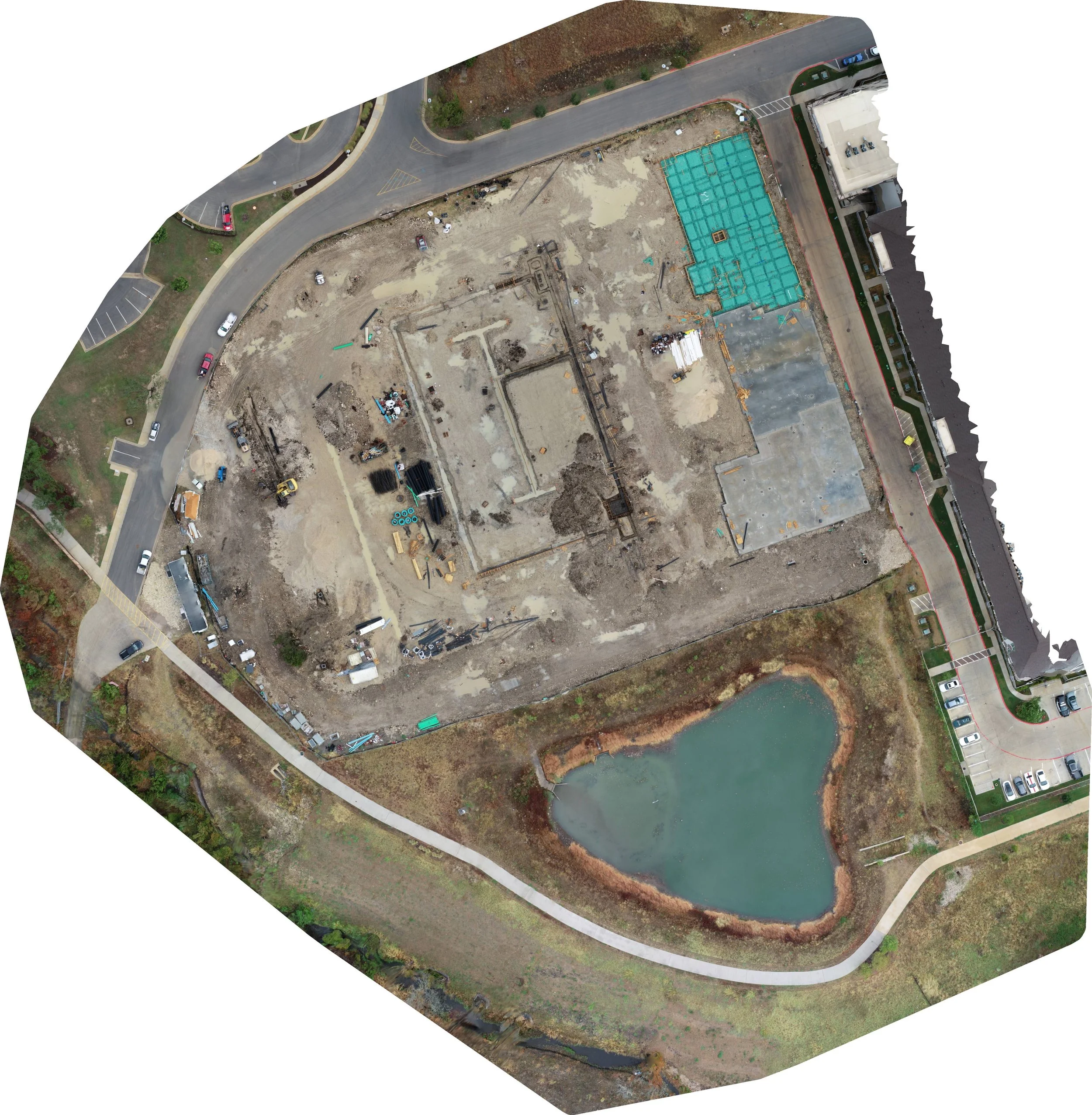

At CriticalEdge, we specialize in providing high-quality aerial documentation services for construction companies throughout Texas. Our drone-based data collection solutions support project managers, superintendents, and project owners, ensuring improved communication and enhanced project oversight on construction sites.
Key Benefits of Our Aerial Documentation Services:
Enhanced Communication: Real-time aerial data allows all stakeholders to stay informed and aligned, reducing miscommunication.
Improved Project Oversight: Gain a comprehensive view of the construction site from above, helping you monitor progress efficiently and address potential issues early.
Accurate, Up-to-Date Drone Data for Better Project Tracking and Scheduling: Our aerial deliverables delivers precise, real-time data, making it easier to track project milestones, evaluate site conditions, and keep your construction projects on schedule.
Cost-Effective Solutions: Aerial documentation minimizes the need for frequent on-site visits, resulting in significant time and cost savings. Real-time aerial data makes material inventory and tracking easier, ensuring efficient project management and streamlined operations..
Safety and Compliance: Improve site safety with a comprehensive aerial overview of the entire project. Documenting workers actions and site activities in real-time, we help ensure regulatory compliance and provide full project area awareness. This enhanced visibility increases risk management capabilities and helps reduce safety hazards across the entire construction site.